When you drive a truck for a living, navigation isn’t just part of the job—it is the job. A dependable GPS system helps you stay safe, on schedule, and compliant with all the rules that come with hauling heavy loads. In this guide, we’ll break down the helpful tools, features, and best practices to help you navigate smarter and avoid unnecessary delays.
Why truck-specific GPS systems matter for safety, compliance, and efficiency
A standard GPS can get a car across town just fine—but throw a 40-ton truck into the mix, and it quickly becomes a liability. Truck-specific GPS systems account for your vehicle’s dimensions, truck weight, trailer and cargo requirements.
- Stay safe by avoiding toll roads, low bridges, sharp turns, and roads not built for commercial traffic.
- Stay legal by following routing rules for weight and speed limits, hazardous materials, and local ordinances.
- Work smarter with routes that avoid time-wasting detours and dead ends.
These systems don’t just show the road—they help you stay ahead of trouble.
How proper navigation reduces stress, delays, and fuel costs for truck drivers and fleets
Getting lost or stuck in the wrong place adds more than just frustration—it eats into your bottom line. Good navigation takes a lot off your plate:
- Fewer delays mean better delivery windows and happier customers.
- Lower fuel use by cutting back on idle time, detours, and stop-and-go traffic.
- Less stress because you’re not second-guessing every turn.
Driving becomes smoother when you trust your route.
- Why truck-specific GPS systems matter for safety, compliance, and efficiency
- How proper navigation reduces stress, delays, and fuel costs for drivers and fleets
Key Navigation Features for Commercial Drivers

Not all GPS systems offer what truckers need. Look for data-driven tools designed to match the realities of the road:
- Custom routing based on truck dimensions, weight, and cargo type
Avoid roads your rig has no business being on. A good system tailors routes to your exact specs. - Real-time traffic updates, weigh station alerts, and toll information
Know what’s coming before it slows you down—or costs you money. - Turn-by-turn directions optimized for truck-accessible roads
No more U-turns in tight neighborhoods or last-minute reroutes because of low clearances. - Access to critical points of interest like truck stops, rest areas, and service stations
When you need to refuel, rest, or get repairs, the info should be right at your fingertips.
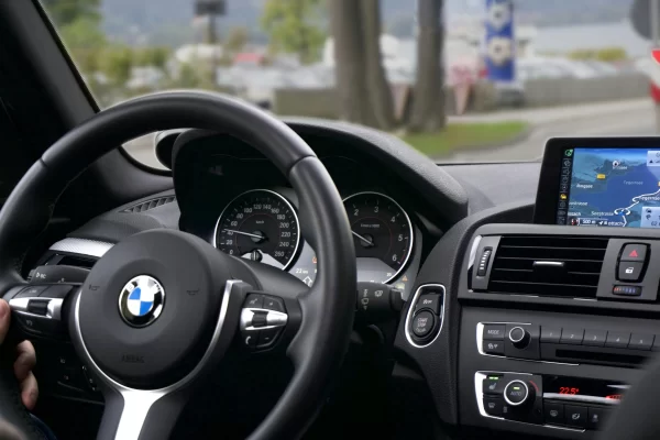
Google Maps for Truck Routing: Pros and Limitations
Google Maps gets a lot right—especially for planning and real-time traffic—but it’s not built for commercial driving.
- Using Google Maps for visual trip planning and live traffic infoGreat for mapping out the big picture and spotting traffic jams in advance.
- Benefits: easy integration and wide POI databaseSimple to use, easy to sync across devices, and loaded with points of interest.
- Limitations: lack of truck-specific restrictions like low bridges or hazmat bansWhat it doesn’t do is warn you about routes that could land you in hot water or worse, damage your truck.
- When to pair Google Maps with a dedicated truck GPS systemUse Google to scope the route. Then let a truck-specific system take over for the detailed, compliant path forward.
Choosing the Right Truck GPS System
There’s a big difference between something that simply “works” and something that works well in real-world conditions. Here’s how to separate the good from the not-good-enough:
- Key features to compare: offline access, custom truck profiles, live updatesMake sure your GPS doesn’t leave you hanging when coverage drops or your truck specs change.
- Device compatibility and integration with other systemsYour GPS should sync smoothly with your dispatch software, phone, and in-cab displays.
- Subscription-based services vs. one-time device purchasesSome systems require ongoing service fees, while others are a one-time buy. Pick based on what fits your setup and future plans.
- Balancing affordability with long-term fleet needsThe cheapest option today could end up costing more in lost time or missed updates. Invest in something that supports daily operations and future growth.
Tips for Safer, Smarter Truck Navigation
Even with the best equipment, good planning and habits still count. Here’s what experienced drivers and fleet managers do to stay ahead:
- Pre-plan routes around load size and delivery schedules- Not all “fastest routes” are right for your truck or load. Plan intentionally.
- Monitor driver fatigue by mapping ideal rest stops- Rest shouldn’t be an afterthought. Know your options before hitting the road.
- Use weigh station alerts to stay compliant- These alerts give drivers time to prepare, saving time and avoiding violations.
- Incorporate weather and road condition updates into daily route checks- A sudden storm or closed road can derail an entire shift. Keep your route flexible and informed.
Why Geotab by Traxxis GPS Stands Out
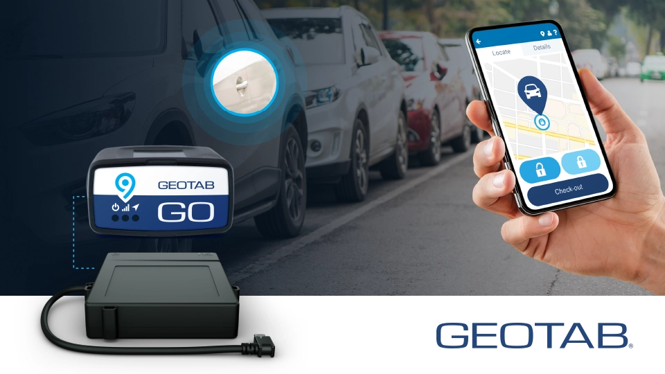
Plenty of GPS systems claim to do it all. But when it comes to commercial trucking, most fall short where it matters—combining navigation, compliance, and fleet management into one easy-to-use platform. Geotab by Traxxis GPS isn’t just a step above—it’s a different league altogether.
- Combines GPS, telematics, and fleet data into a single smart system
Instead of juggling multiple tools and platforms, Geotab pulls everything together. You get location tracking, driver behavior insights, vehicle diagnostics, and routing—all in one clean dashboard. This level of integration gives you a full picture of your fleet’s performance, not just dots on a map. - Real-time trip updates, geofencing, and DOT compliance tracking
Know the instant a driver deviates from their route, enters or exits a zone, or risks a compliance issue. Geofencing allows you to set virtual boundaries around job sites or restricted areas, and DOT compliance tools help ensure that logs, inspections, and hours-of-service reports stay accurate and audit-ready. - Seamless integration with dispatch dashboards, phones, and in-cab displays
The system was built to work where your team already operates. If your dispatchers are in the office or on the go, they can manage routes, push updates, and stay in sync with drivers using mobile apps or in-dash hardware. It’s smooth, fast, and doesn’t get in the way of the job. - Designed for real-world conditions, not just software demos
Geotab by Traxxis has been tested in tough fleet environments—long haul, last mile, multi-stop, and more. It’s not a theory; it’s a proven solution that logistics teams use every day to reduce downtime, improve safety scores, and cut wasted miles. - Backed by Traxxis GPS support and expertise
Having the right technology is one thing. Having people who understand the industry and can help tailor that tech to your business is another. Traxxis brings years of experience helping fleets solve real routing, tracking, and compliance problems—fast.
How Fleets Use Geotab for Smarter Routing
Here’s how smart fleets use Geotab to stay efficient and cut waste:
- Fleet managers send optimized routes directly to drivers
No guessing. Drivers get routes that account for cargo, time, and road conditions. - Monitor live performance, fuel use, and route compliance
Track how each driver and your commercial vehicle are doing—and make adjustments when needed. - Review route history to improve planning and reduce idle time
Look back to move forward. Every trip is a chance to plan better for the next.
Traxxis GPS + Geotab: Built for Growing Fleets
Scaling a fleet doesn’t have to mean more complexity. Traxxis GPS paired with Geotab gives you the flexibility to grow without sacrificing control or efficiency.
- Flexible for any fleet size- From solo drivers to large operations, the system scales smoothly—no platform switch, no headaches.
- Proven to cut costs and boost performance- Logistics teams rely on it to reduce delays, improve safety, and stay on budget across the board.
- Support you can count on- Traxxis is known for responsive, knowledgeable help, while Geotab delivers steady updates to keep your tech sharp.
- Built to fit into your workflow- Seamless integration with dispatch systems and mobile tools means less manual work and faster decisions.
This setup isn’t just ready for growth—it’s built for it.
Final Thoughts
A reliable truck GPS system is more than just a convenience—it’s a key tool for safe and efficient operations. Features like custom routing, real-time traffic alerts, and clear turn-by-turn directions help drivers avoid costly delays and stay compliant on every trip.
As you compare options, think about what matters most for your routes, your loads, and your bottom line. The right navigation solution should fit your daily demands while growing with your fleet.
For a system that does more than just navigate, explore how Geotab by Traxxis GPS delivers real-time visibility, advanced routing tools, and seamless fleet integration—all backed by expert support.
Are you ready to streamline your operations and take the guesswork out of every trip? Contact Traxxis GPS Solutions and discover how you can make your routes smarter and your fleet stronger—mile after mile.